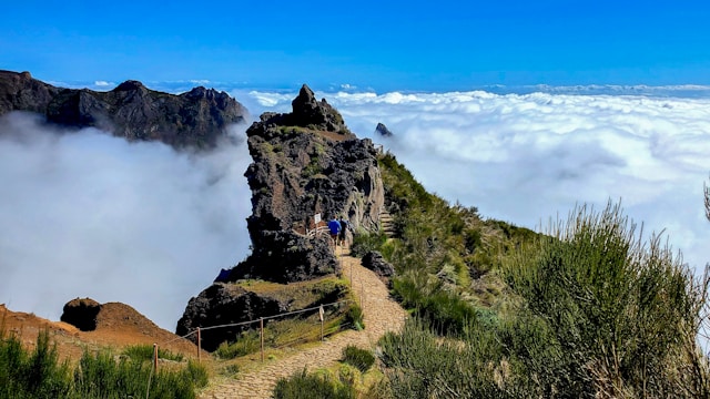
Pico do Arieiro
In Madeira, Portugal .
More places to visit in Madeira
Discover more attractions and things to do in Madeira.
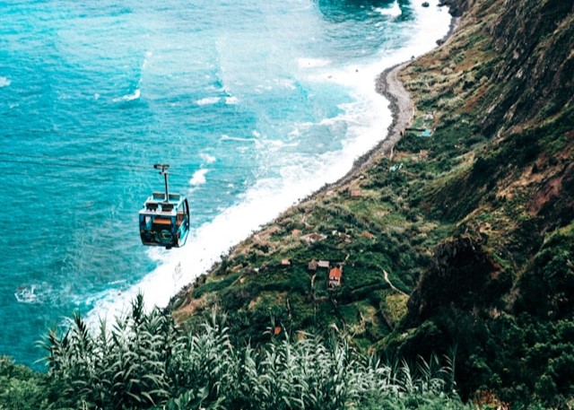
Achadas da Cruz Cable Car
On the northwest coast a tiny station perches above a cliff, and the car drops so sharply it feels like a controlled exhale. The descent lands at Faja da Quebrada Nova , a narrow strip of gardens pinned between rock and ocean, still parceled out in careful rectangles. Locals call this one of the island’s steepest cable car rides, a vertical drop that can startle even seasoned gondola fans. Down on the shore, basalt pebbles clatter softly and old sheds tell how farmers once ferried tools by rope and stubbornness. The ride is short but edits the island into layers—sky, wall, field, sea—so neatly that the brain takes a moment to reorder scale. Check the schedule: weather pauses service when gusts forget their manners, and the kiosk sells the best chocolate you did not know you needed at Achadas da Cruz . Walk the old seaside path for ten minutes and gardens reveal hand-built watering tricks.
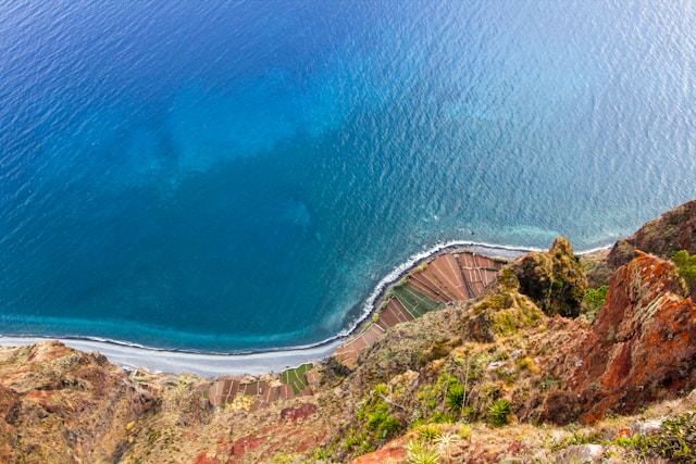
Cabo Girao Skywalk
At the island's south coast, a cliff-top balcony turns gravity into theater as glass panels carry your footsteps above the Atlantic. Numbers matter here: the ledge hangs around 580 meters over terraced fields, so the drop reads like a paragraph you cannot finish. Engineers anchored the platform in 2012 , and guides explain how wind loads and tempered glass make nerves optional. On clear days you trace fishing boats, the cable line to Faja dos Padres , and the geometry of old vineyards. It is not only thrill; farmers once lowered baskets along these walls, proof that agriculture and daring have been neighbors for centuries. Look east and the arc of the Atlantic cliffs draws a crisp horizon; look down and you can count irrigation lines as if reading staff music. Stay for sunset when the cliff's shadow lengthens and the sea becomes a slow mirror, a quiet counterargument to adrenaline. A small quirk: in winter the updraft can lift gulls to eye level, turning the skywalk into a classroom on aerodynamics.
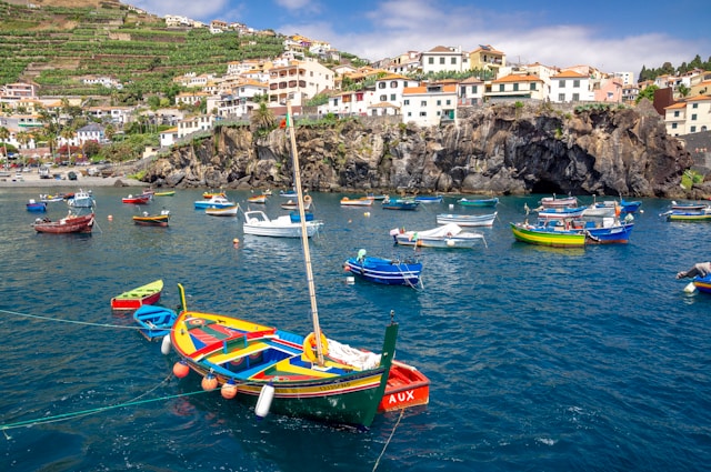
Camara de Lobos Bay
A semicircle of painted boats rests in a pocket harbor, and cafes send clinks of glass across water that barely stirs. Fishermen repair nets with a speed born of repetition, then pose with good humor for curious lenses. The town caught a wider audience when Winston Churchill set up an easel here in 1950 , turning cliffs and hulls into steady brushwork. Order a glass of poncha mixed to a recipe that tilts toward lemon, then watch the tide redraw reflections along the quay. Above the rooftops, banana terraces step toward Cabo Girao , and the geometry makes a quiet case for patience. Evenings bring grilled limpets, garlic, and talk of tomorrow’s forecast, which matters more than any plan on paper. A stroll to the cape viewpoint the next day closes the loop: village, sea, and cliff in one glance, edited by the island’s particular light. The harbor still shelters fishing boats painted in primary colors, a practical palette that brightens the bay when squalls roll through.
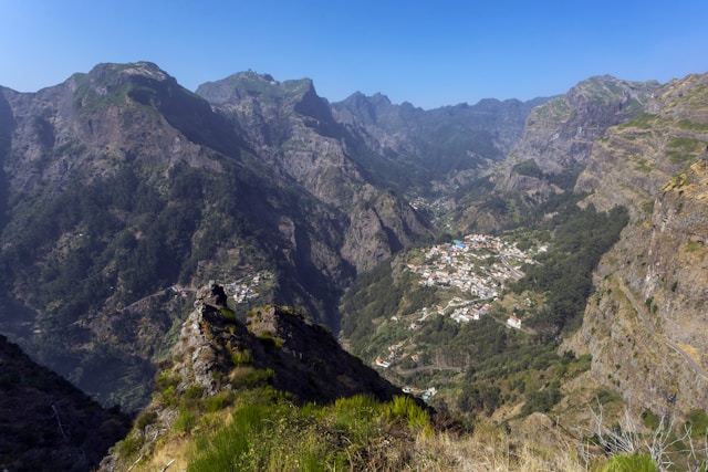
Curral das Freiras
A road of switchbacks climbs above banana terraces until the island opens a basin so steep it feels private. Down below lies Curral das Freiras, a settlement that legend links to nuns seeking refuge in the 16th century when pirates made the coast nervous. The official viewpoint at Eira do Serrado stretches over ridges into a geometry lesson of ravines and folds. Chestnut trees quilt the slopes, and a yearly chestnut festival turns harvest into cakes and soups. Geologists prefer the theory that erosion, not eruption, carved the bowl; drivers prefer a calm passenger and a clear afternoon. From the village, footpaths swing to balconies where the sun arrives late and leaves early. Order a slice of bolo de castanha and you will understand the valley’s rhythm in one bite. From above it resembles a crater like basin , though volcanologists will insist otherwise with friendly certainty. The approach is a study in serpentine road design, each hairpin revealing another ledge of terraced fields and whitewashed eaves.
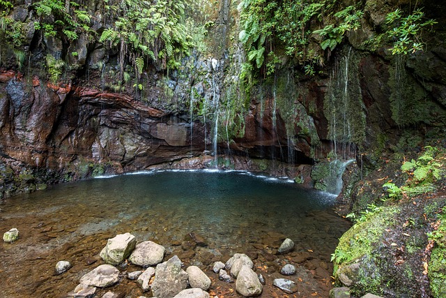
Levada 25 Fontes and Risco
In the Rabacal plateau, water writes its own itinerary along narrow ledges cut into volcanic slopes. The path follows an irrigation channel to a bowl where a curtain of streams gathers, the place locals call the twenty five springs. Along the way, the tall plume of the Risco waterfall marks progress, its spray drifting like punctuation on windy days. These channels, or levadas , began as pragmatic engineering and now double as footpaths that teach patience and balance. Most hikers start at the forest road then descend stairs finished in the 20th century , passing ferns as old as stories and birds that seem to prefer eavesdropping. The wider Rabacal system sits inside the UNESCO listed Laurisilva reserve, so guides talk about endemic plants with the ease of neighbors. Headlamps help in short tunnels, and at the pool the tradition is simple: listen for the separate voices of each fall, then count how many you can hear at once.
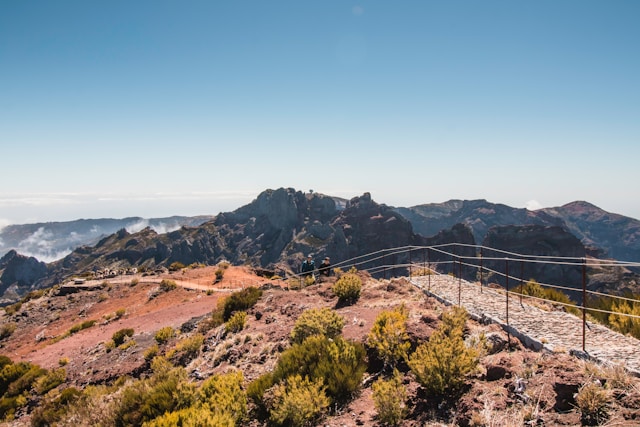
Pico Ruivo
Paths from three directions converge on a summit that feels like a balcony over weather. The figure 1862 meters is plain on the marker, yet the sensation is less about height than reach as ridgelines march away in every compass point. Walkers arrive from Achada do Teixeira or by the exposed link from Pico do Arieiro , counting tunnels and switchbacks like beads. Wooden steps protect fragile slopes, and a small shelter serves tea when cloud rolls in without warning. Botanists point out pockets of the ancient Laurisilva forest below, the remnant that granted Madeira its UNESCO status, and the contrast between green basins and rust rock is startling. At dawn, the Atlantic looks like sheet metal; at noon, islands in the sky drift past as if the weather forgot its lines. The descent teaches patience, and every overlook edits the map you thought you understood. For orientation, the path known as PR1.2 rises from Achada do Teixeira , a steady approach that saves drama for the final crest.
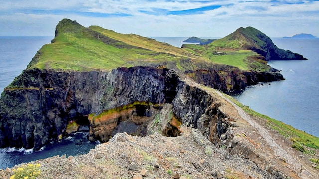
Ponta de Sao Lourenco
At the island’s eastern fingertip, the landscape changes temperament, trading forest for wind and raw rock. A footpath tracks the spine of the peninsula past coves that look quarried by weather, and seabirds draft the upcurrents like seasoned pilots. Geology fans will notice stacks and dikes of basalt and ash, the island’s history laid open without ceremony. The marked PR8 trail rolls over knuckles of land to the shelter at Cais do Sardinha , where water waits like a promise. This is a protected nature reserve , so the palette narrows to straw, rust, and marine blue, with lizards rehearsing sunbaths on every stone. The trade winds keep the air rinsed and the cliffs honest, and on rare calm days the sea turns a polished steel that makes even locals pause. Arrive early and you may have the headlands almost to yourself; arrive late and sunset edits the peninsula into silhouettes that linger long after the walk back.
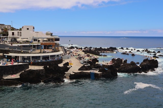
Porto Moniz Natural Pools
On the north coast, lava stopped mid stride and the sea filled the footprints, leaving a series of calm basins linked by steps and low walls. Locals recommend arriving when the tide is kind, because the Atlantic swell sets the mood even on the gentlest days. Attendants keep watch and mark the deepest bowls, and families learn quickly which ledge warms fastest between swims. The pools are true saltwater , refreshed by every surge, and on high swell the outer rim throws spray like applause. Black rock meets turquoise in a palette photographers love, but the trick is to put the camera down and float. Facilities are practical rather than fancy, and lifeguards treat the north coast with the respect it demands. Geologists note that this is a patient collaboration between volcanic flows and tidal cycles ; swimmers just call it perfect. Stay for grilled limpets and a lemon wedge, the island on a plate after the island as a pool.
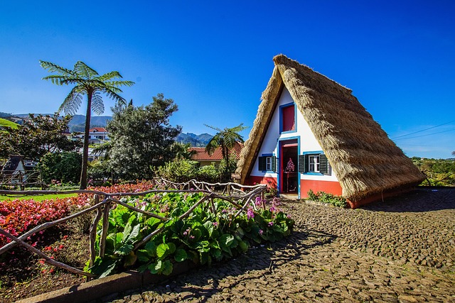
Santana Traditional Houses
On the north coast , triangular houses wear vivid trims and steep thatch , a geometry both practical and surprisingly tough. Farmers built these structures as seasonal shelters tied to agriculture , with lofts for grain and doors sized to keep wind in check. Today a small cluster stands open for visits, showing how tools, blankets, and bread ovens nested inside modest footprints. The design suits the damp: the roofing sheds rain like a cape and insulates well against mountain chill, provided the bundles are replaced on schedule. Interpreters explain the island’s shift from subsistence to tourism without treating the past as scenery, and a signed heritage village area gathers examples for easy comparison. A short hop away, trails reach levadas where hydrangeas blow like confetti across banks, a reminder that working paths became leisure routes. For the record, the official display lists dimensions and maintenance cycles, and the town’s festival banner turns the houses into a cheerful emblem.